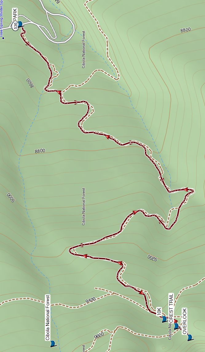
Tree Spring to Pino Canyon Overlook Hike
In Sandia Mountain East Region
Map File Source: Garmin BaseCamp
 Hike Key: H10735
Last Updated: 06/08/2024 3:19pm
Last Updated By: Marilyn Fixer
Hike Class: C (Challenging)
Hike Distance: 4.1 mi
Minimum Elevation: 8473 ft
Elevation Change: 1028 ft
Total Uphill: 1179 ft
Total Downhill: 1179 ft
Avg. Grade: 10 %
Route Type: InOut
On Trail: Yes
Paved or Gravel Roads: Yes
GPS Advised: No
Drive Distance Round Trip: 54 mi
Drive Time One-Way: 0:45
Hiking Seasons: Summer and Fall
New Mexico Game Unit: 8
Hike Status: In Process
Attractions: Forest and Views
Highlights
Lush forest, wildflowers in season.
CautionsDifficult footing due to exposed tree roots and rocky rough trail. Hiking poles recommended.
Trailhead Directions
From Albuquerque drive east on I-40 through Tijeras Canyon and take exit 175 north to Cedar Crest/Turquoise Trail on NM14. Drive north for 6 miles and turn left onto NM536 toward Sandia Crest, then at mile marker 5.5 miles, park on the left at the Tree Springs Trail area (TREESPGPRK). This is a fee area, so be prepared to display your Federal Recreational Lands Pass (Senior or Golden Age), or pay the $3 per vehicle.
Actual Hike
Go uphill from the Tree Springs trailhead until you reach the intersection with the 10K TRAIL (1.9 mi). Continue a short distance to the intersection with the CREST TRAIL (2.0 mi, then to the OVERLOOK (2.1 mi). Return the way you came.
Comments
This trail is well used and weathered and has many tripping hazards such as exposed tree roots, pointy rocks and the like, so hikers should mind their footing while they enjoy the scenery. Tree Spring Trail #147 is outside of the Sandia Wilderness Area, so you may encounter bicycles on this portion of the hike.
The track was obtained from the All Trails website.
Map Filename: TreeSprToPinoCnynOLookMap_AllTrHike GPS File Name: TreeSprToPinoCnynOLookWayTrack_AllTrl
Hike GPS File: Click link to download hike waytrack file
Text Author: Marilyn Warrant
Map Author: Marilyn Warrant
Waypoints Author: Marilyn Warrant
Track Author: All Trails
Maintainer: Not Assigned
Editor: