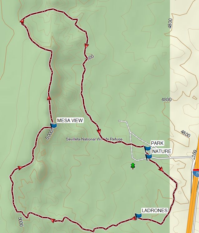
Sevilleta National Wildlife Refuge – Outer Loop Hike
In Socorro Region
Map File Source: Garmin BaseCamp
 Hike Key: H10725
Last Updated: 04/13/2024 7:58pm
Last Updated By: Dawn McIntyre
Hike Class: B (Moderate)
Hike Distance: 4.8 mi
Minimum Elevation: 4790 ft
Elevation Change: 270 ft
Total Uphill: 430 ft
Total Downhill: 430 ft
Avg. Grade: 2 %
Route Type: CW Loop
On Trail: Yes
Paved or Gravel Roads: Yes
GPS Advised: No
Drive Distance Round Trip: 120 mi
Drive Time One-Way: 1:00
Hiking Seasons: Spring, Fall, and Winter
New Mexico Game Unit:
Hike Status: Published
Attractions: Views
Highlights
Great views of Ladron Peak, surrounding mountains, the Rio Grande Valley.
CautionsNone.
Trailhead Directions
I-25 south to exit 169. Take exit and make a sharp right turn and proceed 0.25 miles to the Visitor’s Center. Park in the Visitor’s Center Lot.
Actual Hike
The hike starts out with part of the Nature Loop, followed by the Ladrones Vista Trail, and completed with most of the Mesa View Trail.
Waypoints
PARK: N34 21.090 W106 52.899
NATURE: N34 21.045, W106 52.891
LADRONES: N34 20.714, W106 52.963
MESA VIEW: N34 21.217, W106 53.551
Hike GPS File Name: SevilletaNatWildRefuge-OuterLp_MW.gpx
Hike GPS File: Click link to download hike waytrack file
Text Author: Marilyn Warrant
Map Author: Marilyn Warrant
Waypoints Author: Marilyn Warrant
Track Author: Marilyn Warrant
Maintainer: Not Assigned
Editor: Dawn McIntyre