San Lorenzo Canyon Loop Hike
In Socorro Region
Map File Source: DeLorme
 Hike Key: H10138
Last Updated: 12/15/2020 12:00am
Last Updated By: Marilyn Warrant
Hike Class: C (Challenging)
Hike Distance: 3.9 mi
Minimum Elevation: 5275 ft
Elevation Change: 585 ft
Total Uphill: 510 ft
Total Downhill: 510 ft
Avg. Grade: 7 %
Route Type: CW Loop
On Trail: No
Paved or Gravel Roads: No
GPS Advised: Yes
Drive Distance Round Trip: 140 mi
Drive Time One-Way: 1:30
Hiking Seasons: Spring, Fall, and Winter
New Mexico Game Unit: 13
Hike Status: Published
Highlights
Interesting drive to the trailhead, passing sandstone features. From the ridge, views of the surrounding terrain and peaks, including nearby Polvadera Peak.
CautionsPoles may be useful. There is a rock scramble to get on the trail and an off-trail steep descent.
Trailhead Directions
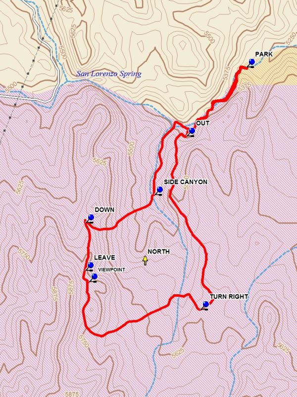
From Albuquerque take I-25 South to exit 163, San Acacia. Go east to the frontage road and go south 2.2 miles and turn right onto a paved road which goes under I-25. After passing through the tunnel stay straight onto a dirt road. Go for 2 miles to a small sign on the right “San Lorenzo Canyon” and turn right. After a short distance the road curves to the left and heads west. Go about 3.4 miles to the canyon barrier and PARK (0.0 mi).
Actual Hike
Find a way up over the barrier on the left side of the canyon. Go up the main canyon for about 0.5 miles. Before reaching a fence across the main canyon go toward the left canyon wall and find a steep road which goes OUT (0.5 mi) up the side of the canyon to a ridge. The next segment of the hike is along this south running ridge. Stay on the rising ridge for about 1 mile. Do not take any side roads. At the 1.4 mile point from the start of the hike there will be a road coming in from the sharp right. TURN RIGHT (1.4 mi) and go toward the arroyo to the north. At this point a road is visible which crosses the arroyo and then goes up the side of the high ridge to the west. Stay on this road until the top of the ridge is reached where there is a good spot for lunch at the VIEWPOINT (2.3 mi). Return to the road and go to LEAVE (2.4 mi) and turn right and follow the ridge to DOWN (2.6 mi). Turn a sharp right and follow a faint roadbed downward until you enter a SIDE CANYON (3.0 mi). Go left down the side canyon until it meets the main canyon and then go right. Then proceed back down the main canyon to the barrier and parking.
Comments
This hike has been redesigned to eliminate encroaching on Sevietta Wildlife Refuge land. This hike is on State Land Office land.
The hike has been changed to C level due to some rock scrambling and steep, off trail descent.
WaypointsPARK: N34 14.406, W107 00.349
OUT: N34 14.137, W107 00.635
TURN RIGHT: N34 13.462, W107 00.568
VIEWPOINT: N34 13.570, W107 01.103
LEAVE: N34 13.614, W107 01.121
DOWN: N34 13.800, W107 01.120
SIDE CANYON: N34 13.909, W107 00.790
Hike GPS File Name: SanLorenzoCanyonLoopWayTrack_DBDB.gpx
Hike GPS File: Click link to download hike waytrack file
Additional File 1 Link Click link to download an additional file.
Text Author: Dick Brown
Map Author: Dick Brown
Waypoints Author: Dick Brown
Track Author: Dick Brown
Maintainer: Cindy McConnell
Editor: Marilyn Warrant
