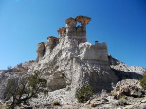
Lybrook Badlands West South To North Hike
In Cuba Region
Map File Source: DeLorme
Last Updated: 06/27/2021 12:00am
Last Updated By: Marilyn Fixer
Hike Class: C (Challenging)
Hike Distance: 5.5 mi
Minimum Elevation: 6870 ft
Elevation Change: 180 ft
Total Uphill: 350 ft
Total Downhill: 350 ft
Avg. Grade: 4 %
Route Type: CCW Loop
On Trail: No
Paved or Gravel Roads: No
GPS Advised: Yes
Drive Distance Round Trip: 260 mi
Drive Time One-Way: 2:30
Hiking Seasons: Spring, Fall, and Winter
New Mexico Game Unit: 7
Hike Status: In Process
Highlights
Hike a wonderland of mesas and hoodoos.
CautionsAll off-trail hike over rough and sometimes difficult terrain. Hiking poles are recommended.
Trailhead Directions
From Albuquerque take I-25 north to Bernalillo. Go west on US 550 through San Ysidro, thru Cuba (reset the odometer here), Go about 48.5 miles from Cuba to the “Chaco Culture” sign and turn left at TO CHACO. Take the road to Chaco until the road to Chaco turns right, turning to dirt. Stay straight on the paved road to the first dirt road on the left TO LYBROOK and turn left. After about 3 miles there will be a view into the badlands. The road descends here. Go about 1 more mile to a road on the left at NORTH TO HIKE. Turn left and proceed about 1.5 miles to PARK.
Comments
The Rating was increased to C because the hike is off trail over rough and sometimes difficult terrain.
WaypointsWELL PAD: N 36 12.147, W 107 36.346
PARK: N 36 11.867, W 107 36.112
WELL ROAD: N 36 12.089, W 107 36.104
PRIVATE: N 36 12.867, W 107 36.118
TWIN TOWERS: N 36 12.893, W 107 35.494
VIEW: N 36 12.077, W 107 35.457
BARRIER: N 36 12.216, W 107 35.728
Hike GPS File Name: LybrookBadlandsWestSouthToNorthWayTrack_DBDB.gpx
Hike GPS File: Click link to download hike waytrack file
Text Author: Dick Brown
Map Author: Dick Brown
Waypoints Author: Dick Brown
Track Author: Dick Brown
Maintainer: Dawn McIntyre
Editor:
