Jemez Falls to Battleship Rock Hike
In Jemez Mountains Region
Map File Source: NG Topo
 Hike Key: H10207
Last Updated: 06/27/2021 12:00am
Last Updated By: Marilyn Fixer
Hike Class: B (Moderate)
Hike Distance: 3.9 mi
Minimum Elevation: 6771 ft
Elevation Change: 1205 ft
Total Uphill: 448 ft
Total Downhill: 1578 ft
Avg. Grade: 12 %
Route Type: Oneway
On Trail: Yes
Paved or Gravel Roads: Yes
GPS Advised: No
Drive Distance Round Trip: 140 mi
Drive Time One-Way: 1:15
Hiking Seasons: Spring, Summer, and Fall
New Mexico Game Unit: 6A
Hike Status: Published
Highlights
Huge, shiny obsidian boulders. Trail follows the East Fork of the Jemez much of the way. Great views of the rim of San Diego Canyon far off to the west. Tall pines, ponderosas, oak, even alfalfa.
CautionsA mostly downhill trail with steep sections. Watch for poison ivy around the spring.
Trailhead Directions
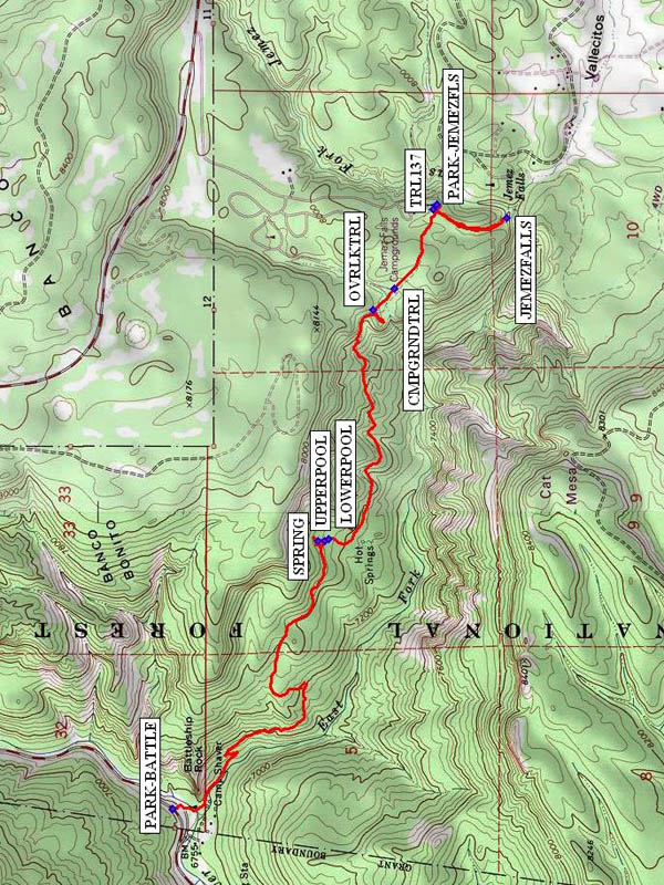
I-25 north to Exit 242, west on US 550 to San Ysidro. Right (north) on SR 4 to La Cueva. Go right, continuing on SR 4 for 5.5 miles past mile marker 32. Right on Jemez Falls Rd (FR 133) for 1.5 mi. past Jemez Falls CG to PARK-JEMEZFLS (0.0 mi). Move one of the vehicles to the Battleship Rock Picnic Area (PARK-BATTLE (3.9 mi)).
Actual Hike
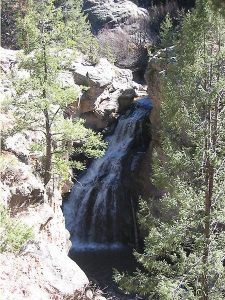
Begin by hiking south to the JEMEZFALLS (0.3 mi) overlook, then return to the junction with TRL137 (0.0 mi) and hike northwest. Go by the junction with the CMPGRNDTRL (0.9 mi), reach the OVRLKTRL (1.1 mi), and hike southwest for a very short distance to a spectacular overlook of the canyon below. Return to the junction and continue northwest, passing through tall pines, ponderosas, oak, even alfafa. There are some uphill sections, despite the general, steep downhill course. Continue to UPPERPOOL (2.2 mi) and LOWERPOOL (2.2 mi), then have lunch at the SPRING (2.2 mi). Some hikers may want to bring their swimsuit for a dip in the Upper Pool. After lunch continue northwest, passing some huge obsidian boulders. Enjoy great views of Battleship Rock and arrive at PARK-BATTLE (3.9 mi). The drivers will return to the Falls to retrieve the van.
Comments
It is a good idea to contact the Forest Service before doing this hike, as the gate to the Falls area is sometimes locked. This hike requires a shuttle, with one vehicle parked at PARK-BATTLE and the other at PARK-JEMEZFLS, so the van’s travel distance will be longer than stated. Allow an extra 30-40 min to round up the shuttle vehicle and load the van. There are some steep parts. You may encounter nudists bathing in the spring. Huge boulders of obsidian — volcanic glass that looks like shiny coal. You’ll follow the East Fork of the Jemez much of the way. Great views of the rim of San Diego Canyon far off to the west. Tall pines, ponderosas, oak, even alfalfa. The hike rating is raised to a B since there are steep parts (even though downhill).
WaypointsPARK: N 35 48.972, W 106 36.391
TRL137: N 35 48.984, W 106 36.409
JEMEZFALLS: N 35 48.762, W 106 36.442
CMPGRNDTRL: N 35 49.101, W 106 36.707
OVRLKTRL: N 35 49.166, W 106 36.786
LOWERPOOL: N 35 49.300, W 106 37.636
SPRING: N 35 49.335, W 106 37.645
UPPERPOOL: N 35 49.313, W 106 37.644
PARK-BATTLE: N 35 49.772, W 106 38.642
Hike GPS File Name: JemezFallstoBattleshipRockWayTrack_HCHC.gpx
Hike GPS File: Click link to download hike waytrack file
Text Author: Roger Holloway
Map Author: Marilyn Warrant
Waypoints Author: Howard Carr
Track Author: Howard Carr
Maintainer: Howard Carr
Editor: Marilyn Warrant
