Crest House to North Peak Hike
In Sandia Mountain East Region
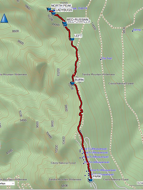
Map File Source: Garmin BaseCamp
 Hike Key: H10721
Last Updated: 06/13/2024 2:30pm
Last Updated By: Marilyn Warrant
Hike Class: C (Challenging)
Hike Distance: 4.1 mi
Minimum Elevation: 10230 ft
Elevation Change: 420 ft
Total Uphill: 810 ft
Total Downhill: 810 ft
Avg. Grade: 2 %
Route Type: InOut
On Trail: Yes
Paved or Gravel Roads: Yes
GPS Advised: Yes
Hiker Limit (NF/BLM/NP): 15 (Sandia Wilderness)
Drive Distance Round Trip: 64 mi
Drive Time One-Way: 0:45
Hiking Seasons: Summer and Fall
New Mexico Game Unit: 8
Hike Status:
Attractions: Fall Color, Forest, Views, and Wildflowers
Highlights
Views from the Sandias to the west and north. Wildflowers in season; limestone cliffs.
CautionsNone
Trailhead Directions
I-40 east to Tijeras exit, north on NM 14, go west on Crest Rd. 536, and PARK (0.0 mi) at the Crest Parking Lot.
Actual Hike
Hike north on the Crest Trail. There are various side trails to the west for views of Albuquerque below. You’ll go by a BURN (1.1 mi) area from a small wildfire. At about 1.5 mi, keep your eye out for an unmarked trail on your LEFT (west). Shortly after, follow the trail to the right (north). There are two Medallion trees close together at 1.8 mi: the Charles I King of England Tree (MED-CHARLES) and the 1st Romanov Russian Tsar Tree (MED-RUSSIAN). You may come across some amazing concentrations of LADYBUGS (1.9 mi). Have lunch at NORTH PEAK (2.1 mi), then return the way you came.
Comments
Coralbells may be found at North Peak and at several other locations along the trail.
WaypointsPARK: N35 12.655 W106 26.929
BURN: N35 13.475 W106 27.119
LEFT: N35 13.847, W106 27.122
MED-CHARLES: N35 13.968, W106 27.195
MED-RUSSIAN: N35 13.985, W106 27.202
LADYBUGS: N35 14.066, W106 27.318
NORTH PEAK: N35 14.102, W106 27.366
Hike GPS File Name: CrestHouseToNorthPeak.gpx
Hike GPS File: Click link to download hike waytrack file
Text Author: Marilyn Warrant
Map Author: Marilyn Warrant
Waypoints Author: Marilyn Warrant
Track Author: Marilyn Warrant
Maintainer: Not Assigned
Editor: Dawn McIntyre