Bear Mouth Inside Hike
In Cabezon Region
Map File Source: NG Topo
 Hike Key: H10457
Last Updated: 06/29/2021 12:00am
Last Updated By: Marilyn Fixer
Hike Class: C (Challenging)
Hike Distance: 4.7 mi
Minimum Elevation: 7368 ft
Elevation Change: 713 ft
Total Uphill: 1152 ft
Total Downhill: 1152 ft
Avg. Grade: 8 %
Route Type: Lollypop
On Trail: No
Paved or Gravel Roads: No
GPS Advised: Yes
Drive Distance Round Trip: 174 mi
Drive Time One-Way: 1:45
Hiking Seasons: Spring, Summer, and Fall
New Mexico Game Unit: 9
Hike Status: Published
Access Description: Cabezon Area Access
Highlights
Spectacular views, interesting geology, swirls of columnar lava, wildlife, wildflowers.
CautionsSome bushwhacking, one steep uphill and one steep downhill may challenge some hikers. Trekking poles are recommended.
Trailhead Directions
From Albuquerque, take I-25 North to Bernalillo. Exit 242 and go west on US550. Drive northwest on US-550 to Mile Marker 41 (18 miles from San Ysidro) and turn left (west) at sign marked San Luis-Cabezon. You will be leaving US550 onto County Road (CR) 279. Zero out the odometer here.
Drive past the intersection with TORREON RD (8.4 mi) where the paved road changes to a dirt road. Stay southwest and west on CR279 passing by junctions with BLM 1114 (JCTBLM1114 (12.3 mi)), then BLM 1102 (JCTBLM1102 (13.7 mi)). At the junction with BLM 1129 (JCTBLM1129 (16.9 mi)), turn left or south. You will cross a one-lane BRIDGE (20.0 mi). Turn right or north at junction with BLM 1103 (JCTBLM1103 (21.4 mi)). Go another 4.2 mi to the gate at Hunter’s Camp where there is a place to park on the right (PARK 0.0 mi).
Actual Hike
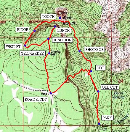
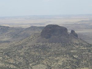
Start hiking north over a rough, but cairn-marked trail to OLD CDT (0.4 mi) where the old Continental Divide Trail (CDT) is now completely grown over. Continue hiking and you will find the well-marked CDT (0.7 mi). Make an abrupt left turn and follow the CDT up the ridge of the mesa and across the flat top to ROAD & CDT (1.3 mi). Turn right (north) leaving the Continental Divide Trail to the high point on the mesa where you may find a GEOMARKER (1.9 mi). From there continue north to JUNCTION (2.1 mi) and then to the dazzling edge of mesa at LUNCH (2.3 mi) looking down at the bear’s tooth.
After the spectacular panoramic view at lunchtime, retrace your tracks to JUNCTION where you will veer to the right (southwest) and begin some bushwacking through the dense forest. At WEST PT (2.7 mi) it is important to identify a cairn and keep following the well-placed cairns to RIDGE (2.9 mi) and then down the steep slope via switch backs all the way to TOOTH (3.3 mi).
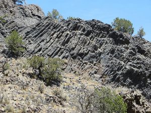
Spend a half an hour there, marveling at the soft-ice cream-like swirls of columnar lava on the bear tooth volcanic plug. It’s really a sight to behold! From the meadow (the mouth of the bear) between the huge bear tooth and the gigantic cliff where lunch was eaten, head southeast to traverse back and forth down a steep hill. Keep your eyes open, because this has been a great place for wildflowers. After reaching the valley below, eventually find the trail leading directly south to the vehicle. It’s easy to lose the trail from time to time, but following the WayTrack closely will keep that to a minimum. On the way you will enjoy a PHOTO OP (3.7 mi) and will cross the CDT (4.0 mi) and the OLD CDT (4.3 mi). From there it’s a short distance to PARK (4.7).
Comments
This hike is cooler in summer because of higher elevation and wooded terrain. The hikers will hike part of the way on the CDT and view the bear tooth from both above and below.
Hike data were determined using a Garmin GPSMap 62 and Garmin BaseCamp’s DEM for TOPO U.S. 24K Southwest.
WaypointsHike:
PARK: N35 33.995, W107 15.421
OLD CDT: N35 34.315, W107 15.431
CDT: N35 34.515, W107 15.517
ROAD & CDT: N35 34.298, W107 16.003
GEOMARKER: N35 34.692, W107 16.025
JUNCTION: N35 34.834, W107 16.035
LUNCH: N35 34.956, W107 15.953
WEST PT: N35 34.769, W107 16.318
RIDGE: N35 34.916, W107 16.203
TOOTH: N35 35.040, W107 15.894
PHOTO OP: N35 34.716, W107 15.655
Access:
BRIDGE: N35 35.565, W107 11.470
JCTBLM1102: N35 38.128, W107 07.927
JCTBLM1103: N35 34.899, W107 12.438
JCTBLM1114: N35 37.933, W107 06.487
JCTBLM1129: N35 37.569, W107 11.441
TORREON RD: N35 40.177, W107 03.665
US550 MM41: N35 42.697, W106 56.303
Hike GPS File Name: BearMouthInside1_BG.gpx
Hike GPS File: Click link to download hike waytrack file
Text Author: Bill Gloyd
Map Author: Bill Gloyd
Waypoints Author: Bill Gloyd
Track Author: Bill Gloyd
Maintainer: Bill Gloyd
Editor: Marilyn Warrant


