Hilso TH – Quaking Aspen – Turkey Nest Trails to Sheetrock Tank Hike
In Northwest New Mexico Region
Map File Source: Other
 Hike Key: H10687
Last Updated: 02/28/2024 5:10pm
Last Updated By: Marilyn Fixer
Hike Class: C (Challenging)
Hike Distance: 8 mi
Minimum Elevation: 514 ft
Elevation Change: 731 ft
Total Uphill: 0 ft
Total Downhill: 0 ft
Avg. Grade: 3 %
Route Type: Lollypop
On Trail: Yes
Paved or Gravel Roads: Yes
GPS Advised: Yes
Drive Distance Round Trip: 246 mi
Drive Time One-Way: 2:30
Hiking Seasons:
New Mexico Game Unit: 10
Hike Status: In Process
Cautions
None.
Trailhead Directions
From Albuquerque travel west on I-40 123 miles to Exit 33 for Red Rock Park and Fort Wingate, also the exit for Hwy 400. At the stop sign after exiting I-40, turn left/south on Hwy 400 South. The Hilso Trailhead is located on the west side of Hwy. 400, 7 miles from the I-40 overpass. Hwy. 400 passes Wingate High School and Fort Wingate Park and enters Cibola National Forest. Chemical toilets are located at the trailhead.
Actual Hike
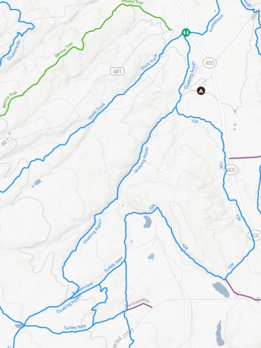
From the Hilso Trailhead parking area proceed south on Quaking Aspen trail located to the west of the chemical toilets. Continue on Quaking Aspen trail at the first trail juncture with Y2K trail. After .7 miles, turn left at the second juncture of trail Y2K continuing a short distance on trail Y2K, crossing a cattle guard and a stock pond on the left. At the trail juncture for Turkey Nest trail, turn right and continue on Turkey Nest trail, passing a fence line with private property on your left. At a Y trail juncture, take the trail to the right with a green and white Trail sign. Do not proceed straight along the fence line! At the next two trail junctures, continue straight on Turkey Nest Trail. The trail juncture signs will show the direction to Sheet Rock Tank. Turkey Nest trail will end at another trail juncture by Sheet Rock Tank. This is a good place to have lunch. The return trip north to the parking area technically starts on trail 0216 although the sign indicates Quaking Aspen. Trail 0216 leads to the next trail juncture where the trail officially becomes Quaking Aspen trail after the juncture. Continue straight on trails 0216 and Quaking Aspen to the Hilso Trailhead parking area.
Comments
The Hilso trailhead is usually closed from mid-December to mid-April due to snowfall and runoff. See the brochure for Gallup area hikes for more information. The source for the map is the TRAILFORKS, McGaffey Mountain Bike Trails website.
Map Filename: HilsoTH-QuakingAspen-TurkeyNestTrailsToSheetrockTank.jpgText Author: Diane Owens
Map Author: Marilyn Warrant
Waypoints Author:
Track Author:
Maintainer: Not Assigned
Editor: