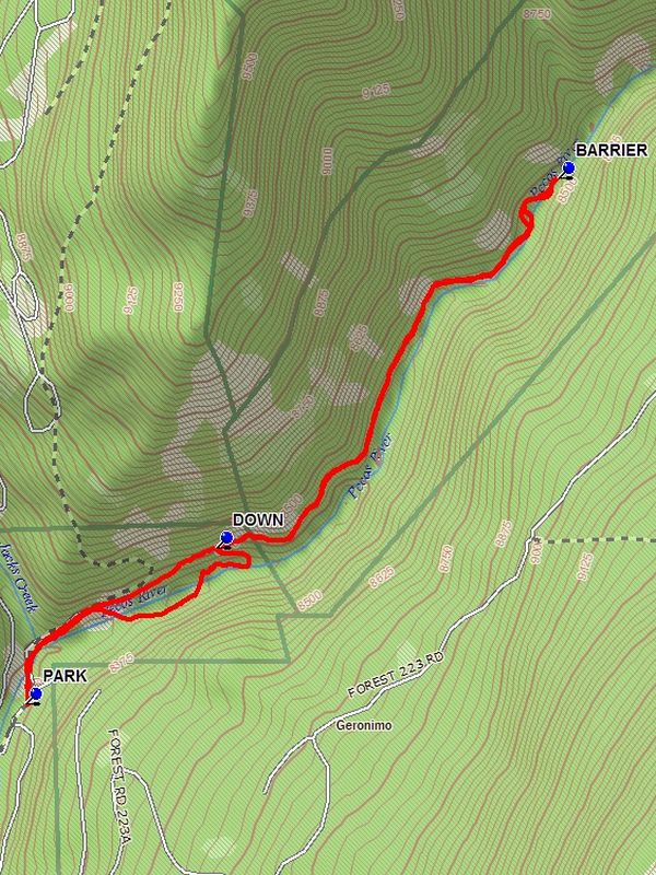
Pecos River Canyon Hike
In Pecos Region
Map File Source: DeLorme
 Hike Key: H10513
Last Updated: 12/15/2020 12:00am
Last Updated By: Marilyn Warrant
Hike Class: B (Moderate)
Hike Distance: 3.4 mi
Minimum Elevation: 8235 ft
Elevation Change: 204 ft
Total Uphill: 225 ft
Total Downhill: 225 ft
Avg. Grade: 5 %
Route Type: InOut
On Trail: Yes
Paved or Gravel Roads: Yes
GPS Advised: Yes
Drive Distance Round Trip: 200 mi
Drive Time One-Way: 2:00
Hiking Seasons: Spring, Summer, and Fall
New Mexico Game Unit: 45
Hike Status: Published
Highlights
Pleasant hike above a babbling river.
CautionsThe use of hiking poles is advised.
Trailhead Directions
From Albuquerque go north on I-25 to Exit 299 Glorieta. Cross over the highway, turn right onto NM 50, and travel 6 mi to the town of Pecos and a junction with NM 63. Turn left, and proceed 20.2 mi to Cowles. Continue straight North for 1 mile to parking on the right just before the bridge that crosses the Pecos River.
Actual Hike
From parking go north along the river to a dwelling where the trail goes to the left of the building and up hill. Follow the trail, staying up on the side of the canyon until you reach the BARRIER (1.6 mi). Then return the way you came to DOWN (2.7 mi) and go left down the trail which doubles back to the north until the river is reached. Turn right and follow the trail along the river and back to parking.
Waypoints
COWLES: N35 48.735, W105 39.534
PARK: N35 49.402, W105 39.311
BARRIER: N35 50.253, W105 38.215
DOWN: N35 49.655, W105 38.919
Hike GPS File Name: PecosRiverCanyonWayTrack_DBDB.gpx
Hike GPS File: Click link to download hike waytrack file
Text Author: Dick Brown
Map Author: Dick Brown
Waypoints Author: Dick Brown
Track Author: Dick Brown
Maintainer: Cindy McConnell
Editor: Marilyn Warrant