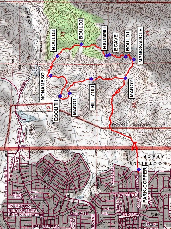
Boulder Ridge Hike
In Sandia Mountain West Region
Map File Source: NG Topo
 Hike Key: H10483
Last Updated: 03/20/2023 2:11pm
Last Updated By: Marilyn Fixer
Hike Class: D (Difficult)
Hike Distance: 6.2 mi
Minimum Elevation: 5930 ft
Elevation Change: 1693 ft
Total Uphill: 2300 ft
Total Downhill: 2300 ft
Avg. Grade: 15 %
Route Type: Lollypop
On Trail: No
Paved or Gravel Roads: Yes
GPS Advised: Yes
Hiker Limit (NF/BLM/NP): 15 (Sandia Wilderness)
Drive Distance Round Trip: 20 mi
Drive Time One-Way: 0:15
Hiking Seasons: Spring and Fall
New Mexico Game Unit: 8
Hike Status: Published
Highlights
Hiking on the boulder ridge offers great views and even an unexpected cave. Walking through the boulders is lots of fun and has you wondering what’s around the corner.
CautionsSteep, so hiking poles recommended.
Trailhead Directions
Take Tramway south to Copper. Go east to the end of road. Park at PARK-COPPER (0.0 mi).
Actual Hike
The hike starts at PARK-COPPER (elev 5930) crossing over the foothill trails until we reach the Mano Trail at MANO2 (1.6 mi), then go east. We stay on this trail until we reach the MANOSADDLE (1.9 mi); we then turn north, working our way across the boulder ridge, encountering a cave near the summit BSUMMIT (2.3 mi). At BOULD3 (3.0 mi), we’ll start working our way down toward waypoint NONAMESO (3.4 mi) (there’s some bushwhacking descending the hill). We’ll follow this trail south to the canyon, then turn west. Walking out of the canyon west, we’ll make a sharp turn south at BSOUTH (3.8 mi) walking back to the Mano Trail MANO1 (4.0 mi)). We’ll continue on the Mano Trail south. When we reach MANO2 (4.85 mi) we’ll turn west, heading back toward the van.
Comments
Hiking on the boulder ridge offers great views and even an unexpected cave. Walking through the boulders is lots of fun and has you wondering what’s around the corner.
WaypointsPARK-COPPER: N35 04.752, W106 29.077
MANO2: N35 04.886, W106 27.983
MANOSADDLE: N35 04.803, W106 27.759
BOULD1: N35 04.883, W106 27.727
BCAVE: N35 05.044, W106 27.703
BSUMMIT: N35 05.070, W106 27.713
BOULD2: N35 05.319, W106 27.578
BOULD3: N35 05.556, W106 27.721
NONAMESO: N35 05.623, W106 27.954
BSOUTH: N35 05.530, W106 28.199
MANO1: N35 05.435, W106 28.166
HILL 7100: N35 05.221, W106 27.990
Hike GPS File Name: BoulderRidgeWayTrackMod_DV.gpx
Hike GPS File: Click link to download hike waytrack file
Text Author: Bill Davidson
Map Author: Marilyn Warrant
Waypoints Author:
Track Author:
Maintainer: Ken Smith
Editor: Marilyn Warrant