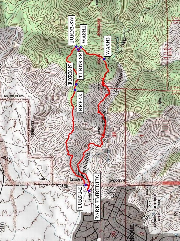
Oso Ridge – Embudito Loop Hike
In Sandia Mountain West Region
Map File Source: NG Topo
 Hike Key: H10470
Last Updated: 12/05/2023 9:41pm
Last Updated By: Marilyn Fixer
Hike Class: D (Difficult)
Hike Distance: 4.4 mi
Minimum Elevation: 6250 ft
Elevation Change: 1503 ft
Total Uphill: 1585 ft
Total Downhill: 1585 ft
Avg. Grade: 14 %
Route Type: CW Loop
On Trail: No
Paved or Gravel Roads: Yes
GPS Advised: Yes
Hiker Limit (NF/BLM/NP): 15 (Sandia Wilderness)
Drive Distance Round Trip: 20 mi
Drive Time One-Way: 0:15
Hiking Seasons: Spring and Fall
New Mexico Game Unit: 8
Hike Status: Published
Highlights
Views that make all the exertion worthwhile.
CautionsThere is a lot of steep rocky uphill (20% grade) in the first two miles. Hiking poles recommended.
Trailhead Directions
Go East on Montgomery almost all the way to the top. Turn left on Glenwood Drive. Drive until you see a brown sign (sign is on the right side of road). Take Trailhead street to Embudito parking lot.
Actual Hike
Start walking from (PARK) up (north) on the bike path for a short distance. Turn right (east) at (TURN1-E) (0.1 mi), then continue up the Oso Ridge. Stop for a short snack (BREAK) (1.3 mi). Continue a short distance and take the left (northern-most) option at the fork (FORK-N) (1.4 mi). Follow this trail until we reach (TURN2-SW) (1.9 mi), and turn right (southwest). This short trail takes us to another trail going generally north/south. Turn left (southeast) at (TURN3-SE) (2.0), then go another short distance to WASH1 (2.1 mi). Follow the wash down (south) until (WASH2) (2.4 mi). We’ll have our lunch here (this spot is on the regular Embudito Trail going east/west). Follow this trail west back to the van.
Comments
There is a lot of steep rocky uphill (20% avg. grade) in the first two miles. Plan on stopping often to keep everyone together. The views at some points are worth all the hard work. The hike is less than 5 mi, but everyone will have a wonderful workout.
WaypointsPARK-EMBUDITO: N35 08.167, W106 28.917
TURN1-E: N35 08.200, W106 28.850
BREAK: N35 08.294, W106 27.810
FORK-N: N35 08.283, W106 27.750
TURN2-SW: N35 08.283, W106 27.333
TURN3-SE: N35 08.267, W106 27.367
WASH1: N35 08.243, W106 27.342
WASH2: N35 08.032, W106 27.469
Hike GPS File Name: OsoRidge-EmbuditoLoopWayTrack_DV.gpx
Hike GPS File: Click link to download hike waytrack file
Text Author: Bill Davidson
Map Author: Marilyn Warrant
Waypoints Author:
Track Author:
Maintainer: Randy Simons
Editor: Howard Carr