La Mesita Blanca East Hike
In Tohajillee Region
Map File Source: DeLorme
 Hike Key: H10316
Last Updated: 12/15/2020 12:00am
Last Updated By: Marilyn Warrant
Hike Class: C (Challenging)
Hike Distance: 7.5 mi
Minimum Elevation: 5730 ft
Elevation Change: 250 ft
Total Uphill: 500 ft
Total Downhill: 500 ft
Avg. Grade: 4 %
Route Type: Loop
On Trail: No
Paved or Gravel Roads: No
GPS Advised: Yes
Drive Distance Round Trip: 100 mi
Drive Time One-Way: 1:15
Hiking Seasons: Spring, Fall, and Winter
New Mexico Game Unit: 9
Hike Status: Published
Highlights
Hike to an area with extensive red rock objects and formations. Visit a small mesa with great views. Hike up a canyon containing numerous formations.
CautionsThis hike is off trail.
Trailhead Directions
From Albuquerque take I-40 West to the Tohajillee exit. Go north to the village. Just before the school area, turn right over a CATTLE GUARD with yellow sides (7.8 mi from I-40 interchange). Then an immediate left. Drive for about 8 miles, taking the obvious main road at any turns. At T TURN go a sharp right and proceed for 1.0 miles to PARK (0.0 mi) on the left before the fence gate.
Actual Hike
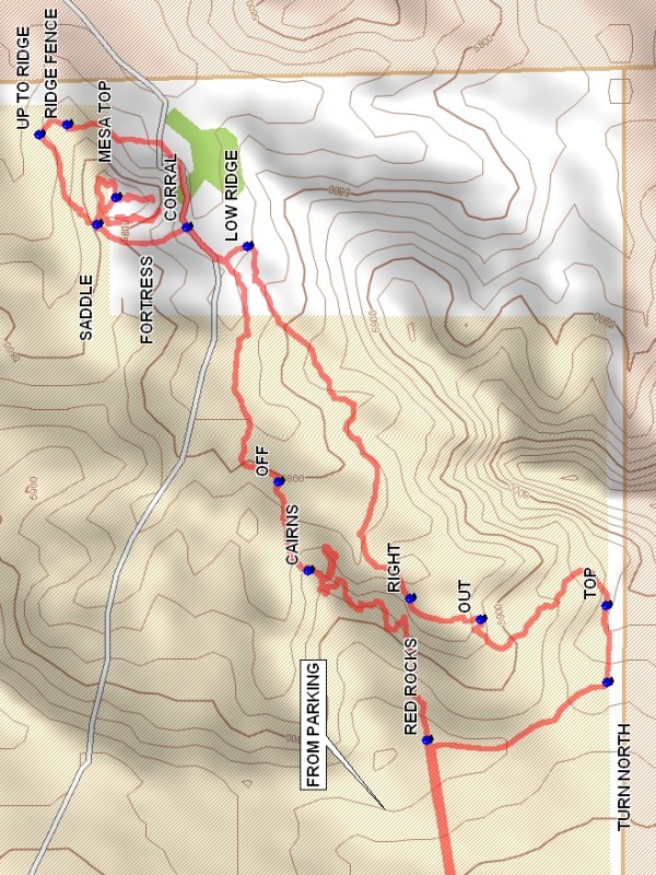
Go through the fence gate (close it after you) and turn east and go 1.7 miles while moving away from the parallel fence slightly uphill until RED ROCKS (1.7 mi) where a two track goes north/south near the edge of a drop off. There will be red rock formations ahead. Go along the edge of the canyon on your right. The large mesa cross the canyon is the La Mesita Blanca. After reaching the CAIRNS (2.3 mi) go down and along a narrow ridge to the low mesa ahead and head eastward down the ridge until you go OFF (2.4 mi) onto the flat. Keep to the left side of the flat until you reach the CORRAL (2.9 mi). Turn left in the corral and go up the side arroyo which goes up along the west side of the large mesa until the SADDLE (3.1 mi) is reached. Go right onto the mesa edge and go back south until the FORTRESS (3.2 mi) is reached. Then turn back and as you near the saddle go right up to the MESA TOP (3.4 mi) and wander around. Go back to the saddle and go northeast and down off of the mesa and along it’s north side to UP TO RIDGE (3.9 mi) where a fence is seen on the ridge above. Find a way up to the RIDGE FENCE (3.9 mi) and pass over it. Go down the other side and go back along the mesa base to the corral. Pass through the corral and head toward the LOW RIDGE (4.3 mi) on the other side of the flat. Go up on the low ridge and follow it until the flat begins to narrow. Cross back to the north side of the canyon and enter the narrowing canyon. Once in the narrow canyon there will be a wye. Take the RIGHT (5.0 mi) branch and follow the winding canyon until it ends. There will be a faint path which will go up to OUT (5.1 mi) where you squeeze past a small tree. You will be in a small deep wash. Go out of the wash and bear south. After about 100 feet re-enter and cross the wash and go south uphill until a fence is seen at the TOP (5.5 mi). A washed out road will take you up to the edge where a road will run along the fence. The road will TURN NORTH (5.6 mi) and run along the edge back to RED ROCKS. From there go west back to parking.
Waypoints
CATTLE GUARD: N 35 05.820, W 107 06.662
PARK: N 35 11.381, W 107 05.160
RED ROCKS: N 35 11.615, W 107 03.421
CAIRNS: N 35 11.770, W 107 03.151
OFF: N 35 11.808, W 107 03.010
CORRAL: N 35 11.927, W 107 02.605
SADDLE: N 35 12.045, W 107 02.600
FORTRESS: N 35 11.961, W 107 02.583
MESA TOP: N 35 12.020, W 107 02.557
RIDGE FENCE: N 35 12.083, W 107 02.441
UP TO RIDGE: N 35 12.119, W 107 02.457
LOW RIDGE: N 35 11.848, W 107 02.635
RIGHT: N 35 11.637, W 107 03.196
OUT: N 35 11.545, W 107 03.228
TOP: N 35 11.381, W 107 03.207
TURN NORTH: N 35 11.380, W 107 03.330
Hike GPS File Name: LaMesitaBlancaEastWayTrack_DBDB.gpx
Hike GPS File: Click link to download hike waytrack file
Text Author: Dick Brown
Map Author: Marilyn Warrant
Waypoints Author: Dick Brown
Track Author: Dick Brown
Maintainer: Not Assigned
Editor: Howard Carr