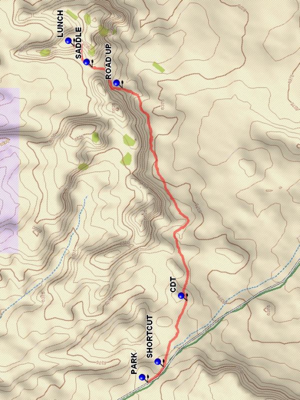
Continental Divide North From La Leña Hike
In Cabezon Region
Map File Source: DeLorme
 Hike Key: H10274
Last Updated: 12/15/2020 12:00am
Last Updated By: Marilyn Warrant
Hike Class: B (Moderate)
Hike Distance: 5.2 mi
Minimum Elevation: 6360 ft
Elevation Change: 255 ft
Total Uphill: 350 ft
Total Downhill: 350 ft
Avg. Grade: 4 %
Route Type: InOut
On Trail: Yes
Paved or Gravel Roads: No
GPS Advised: Yes
Drive Distance Round Trip: 160 mi
Drive Time One-Way: 2:00
Hiking Seasons: Spring, Fall, and Winter
New Mexico Game Unit: 7
Hike Status: Published
Access Description: Cabezon Area Access
Highlights
Easy walk along the bottom of a mesa with sandstone & mudstone features. At top, views to the north backcountry.
CautionsNone.
Trailhead Directions
From Albuquerque take I-25 north to Bernalillo. At Bernalillo take US 550 to San Ysidro. Drive west 18 mi. past intersection of SR 4 and US 550 in San Ysidro to San Luiz Rd. Turn Left and go 12.5 mi. on San Luis Road (past Torreon Rd.), go to the right at TURN1 then turn right on BLM 1102 after another 1.4 miles at TURN2. Go uphill for another 4.7 mi, and PARK (0.0 mi) at the top of a rise on the two-track road on the left.
Actual Hike
From parking go back down the road to the point SHORTCUT (0.1 mi) and leave the road. Go in a south easterly direction following an animal track the point where the Continental Divide Trail crosses the path at CDT (0.6 mi). There will be cairns marking the trail. Go left (east). The trail is fairly well marked and goes along the base of the mesa to the north. There is a variety of formations along the route, as well as a view to the south down the Rio Puerco valley. A ROAD UP (2.1 mi) will take you on a traverse to a SADDLE (2.4 mi) on the mesa. The trail continues on the north side of the ridge to a steep climb to the LUNCH (2.6 mi) spot with good views northward. Another option is to continue north beyond the saddle to interesting formations to the northeast for lunch. Return the way you came for a different view of the terrain.
Waypoints
TURN1: N 35 37.926, W 107 06.500
TURN2: N 35 38.135, W 107 07.938
PARK: N 35 41.141, W 107 10.836
SHORTCUT: N 35 41.059, W 107 10.734
CDT: N 35 40.937, W 107 10.308
ROAD UP: N 35 41.277, W 107 08.934
SADDLE: N 35 41.432, W 107 08.801
LUNCH: N 35 41.528, W 107 08.665
Hike GPS File Name: ContinentalDivideNorthFromLaLenaWayTrack_DBDB.gpx
Hike GPS File: Click link to download hike waytrack file
Text Author: Dick Brown
Map Author: Marilyn Warrant
Waypoints Author: Dick Brown
Track Author: Dick Brown
Maintainer: Bill Gloyd
Editor: Marilyn Warrant