Bear Mouth Hike
In Cabezon Region
Map File Source: NG Topo
 Hike Key: H10273
Last Updated: 12/15/2020 12:00am
Last Updated By: Marilyn Warrant
Hike Class: C (Challenging)
Hike Distance: 5.1 mi
Minimum Elevation: 7490 ft
Elevation Change: 597 ft
Total Uphill: 987 ft
Total Downhill: 987 ft
Avg. Grade: 9 %
Route Type: Lollypop
On Trail: No
Paved or Gravel Roads: No
GPS Advised: Yes
Drive Distance Round Trip: 174 mi
Drive Time One-Way: 1:45
Hiking Seasons: Spring and Fall
New Mexico Game Unit: 9
Hike Status: Published
Access Description: Cabezon Area Access
Highlights
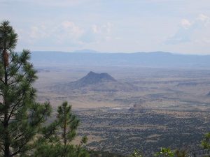
Great views from the mesa and the Bear Mouth.
CautionsSome bushwhacking.
Trailhead Directions
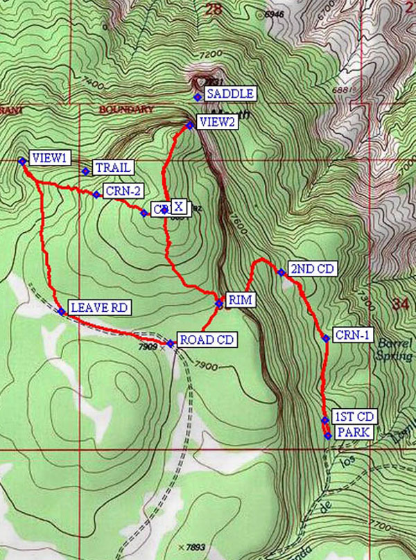
From Albuquerque take I-25 north to Bernalillo. At Bernalillo take US 550 to San Ysidro. Drive west 18 mi. past intersection of SR 4 and US 550 in San Ysidro to San Luis Rd. Set odometer here since all distances mentioned are from this point. (See the access map for details.) Turn left and drive 8.5 miles to Torreon Rd just after a cattle guard. Don’t turn; go straight on the dirt road. Stay on what is obviously the main road. At about 17.75 miles stay to the right, don’t turn left to Cabezon. When you come to a “Y” take the left part. At 19.34 miles, you will go down off the mesa. At about 20.7 miles you will cross the bridge over the Chico Wash (BRIDGE). At 22.1 miles, you will go straight past the left turn-off to Guadalupe Ruin (WP3). At 22.8 miles, you will be at the Hunter’s Camp (on the right-there may be a sign). At this point (WP4) take the road going straight toward the mesa. Don’t go right. In about 3.57 miles (approx. 26.3 from Hiway 550) you will come to a gate. PARK (0.0 mi) here even if it’s open. You don’t save any distance driving up any farther. It’s a steep, rough and rocky road.
Actual Hike
Begin walking north to find the old Continental Divide Trail (1ST CD (0.1 mi)). Follow it to the new trail (2ND CD (0.6 mi)) and turn west on it to go up to the mesa RIM (1.1 mi), and on to an old ROAD CD (1.3 mi). Go right on the road, then LEAVE RD (1.7 mi) and go north-northwest to VIEW1 (2.3 mi). After enjoying the vistas, head east to find the TRAIL that comes up from below the north edge. Follow it to VIEW2 (3.2 mi), which looks right down on the Bear Mouth. Alternatively, find the trail marked by cairns (CRN-2 (2.6 mi) and CRN-3 (2.8 mi)) that leads to X (2.9 mi), then follow the trail to VIEW2 (3.2 mi). Have lunch here after finding the perfect spot to see the whole Rio Puerco region to the east, or other super views to the north and west. After lunch head back south to X, then back down to RIM, to meet the Continental Divide Trail again and retrace your path back to the van. It’s a nice trail in the trees. After you get up on the mesa, the elevation changes on the rest of the hike are hardly noticeable.
Comments
Don’t go if the road is muddy. You’ll go about 21 miles just to find out you can’t go any farther. Great views from the mesa and the Bear Mouth. A good time to go might be late April – early May.
WaypointsBRIDGE: N35 35.565, W107 11.470
SADDLE: N35 35.042, W107 15.903
TRAIL: N35 34.819, W107 16.318
WPT3: N35 34.891, W107 12.429
WPT4: N35 35.045, W107 13.157
PARK: N35 34.020, W107 15.424
1ST CD: N35 34.067, W107 15.433
CRN-1: N35 34.315, W107 15.431
2ND CD: N35 34.514, W107 15.595
RIM: N35 34.418, W107 15.824
ROAD CD: N35 34.298, W107 16.003
LEAVE RD: N35 34.396, W107 16.405
VIEW1: N35 34.848, W107 16.552
CRN-2: N35 34.747, W107 16.278
CRN-3: N35 34.692, W107 16.101
X: N35 34.699, W107 16.028
VIEW2: N35 34.955, W107 15.933
Hike GPS File Name: BearMouthWayTrack_MWFA.gpx
Hike GPS File: Click link to download hike waytrack file
Text Author: Frances Arnold
Map Author: Marilyn Warrant
Waypoints Author: Frances Arnold
Track Author: Marilyn Warrant
Maintainer: Bill Gloyd
Editor: Marilyn Warrant
