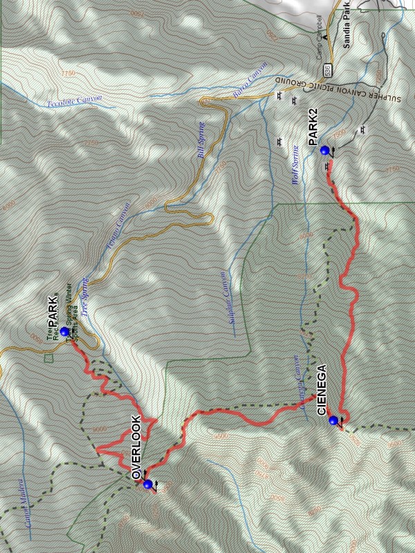
Tree Spring – Crest – Cienega Hike
In Sandia Mountain East Region
Map File Source: DeLorme
 Hike Key: H10212
Last Updated: 03/20/2023 2:44pm
Last Updated By: Marilyn Fixer
Hike Class: C (Challenging)
Hike Distance: 6 mi
Minimum Elevation: 7477 ft
Elevation Change: 2023 ft
Total Uphill: 1228 ft
Total Downhill: 2225 ft
Avg. Grade: 12 %
Route Type: Oneway
On Trail: Yes
Paved or Gravel Roads: Yes
GPS Advised: No
Hiker Limit (NF/BLM/NP): 15 (Sandia Wilderness)
Drive Distance Round Trip: 50 mi
Drive Time One-Way: 0:45
Hiking Seasons: Summer
New Mexico Game Unit: 8
Hike Status: Published
Highlights
Lush forest and wildflowers.
CautionsNone.
Trailhead Directions
I-40 East to Tijeras Exit 175. North on NM 14, west on Crest Highway 536 to the Tree Spring trailhead, and PARK (0.0 mi). It is the second double-back to the right after Doc Long Picnic Area. Shuttle vehicle(s) back down to Cienega Picnic Area at PARK2 (6.0 mi).
Actual Hike
Hike west up to the OVERLOOK (2.0 mi), then go back down to the intersection with the CREST (1.9 mi) Tr., and then south on the Crest Tr. to the CIENEGA (3.9 mi) Tr., then downhill and east on Cienega to the Cienega Picnic Area to meet up with the shuttled vehicle.
Waypoints
PARK: N 35 11.628, W 106 24.274
CREST: N 35 11.227, W 106 25.246
OVERLOOK: N 35 11.162, W 106 25.321
CIENEGA: N 35 10.124, W 106 24.884
PARK2: N 35 10.172, W 106 23.033
Hike GPS File Name: TreeSpring-Crest-CienegaWayTrack_JBJB.gpx
Hike GPS File: Click link to download hike waytrack file
Text Author: Roger Holloway
Map Author: Marilyn Warrant
Waypoints Author: John Boyd
Track Author: John Boyd
Maintainer: Not Assigned
Editor: Marilyn Warrant