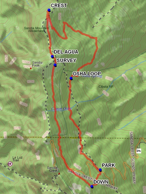
10K – Osha Loop – Survey Hike
In Sandia Mountain East Region
Map File Source: DeLorme
 Hike Key: H10140
Last Updated: 03/20/2023 2:48pm
Last Updated By: Marilyn Fixer
Hike Class: D (Difficult)
Hike Distance: 8.4 mi
Minimum Elevation: 9232 ft
Elevation Change: 1183 ft
Total Uphill: 1586 ft
Total Downhill: 1586 ft
Avg. Grade: 8 %
Route Type: CCW Loop
On Trail: Yes
Paved or Gravel Roads: Yes
GPS Advised: No
Hiker Limit (NF/BLM/NP): 15 (Sandia Wilderness)
Drive Distance Round Trip: 60 mi
Drive Time One-Way: 1:00
Hiking Seasons: Spring, Summer, and Fall
New Mexico Game Unit: 8
Hike Status: Published
Highlights
A hike in the woods with good views to the west.
CautionsSome bushwhacking at the north end. Trekking poles recommended.
Trailhead Directions
I-40 to Tijeras exit 175, north on SR 14 to Crest Road 536 to 10K Trailhead (Trail 200) which is past milepost 10 and PARK (0.0 mi). A three dollar fee or Golden Age Pass is required.
Actual Hike
The 10K trail starts at west end of parking area, follows the road for a bit then heads north. It is well marked with blue diamond blazes and yellow bird signs. Go around the OSHA LOOP (1.9 mi) until you reach the CREST (4.5 mi) trail and find a good place for lunch. Continue south passing the DEL AGUA (5.4 mi) overlook, and return using the SURVEY (5.5 mi) trail. You’ll have to bushwhack DOWN (8.0 mi) and cross the road to the parking area for another half mile.
Comments
Trail is so named because it generally follows the 10,000′ contour line.
WaypointsPARK: N35 12.587, W106 26.123
OSHA LOOP: N35 13.952, W106 26.654
CREST: N35 14.970, W106 27.056
DEL AGUA: N35 14.276, W106 26.996
SURVEY: N35 14.150, W106 26.945
DOWN: N35 12.339, W106 26.277
Hike GPS File Name: 10K-OshaLoop-SurveyWayTrack_JBJB.gpx
Hike GPS File: Click link to download hike waytrack file
Text Author: Roger Holloway
Map Author: Marilyn Warrant
Waypoints Author: John Boyd
Track Author: John Boyd
Maintainer: Ken Smith
Editor: Marilyn Warrant