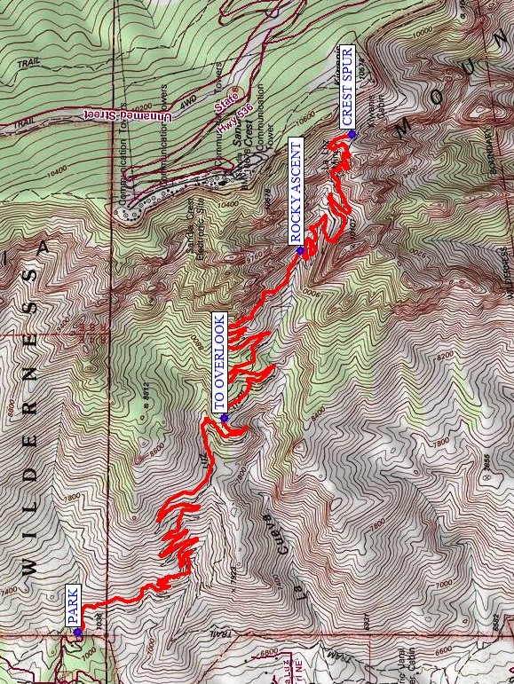
La Luz Round-Trip Hike
In Sandia Mountain East Region
Map File Source: NG Topo
 Hike Key: H10681
Last Updated: 12/15/2020 12:00am
Last Updated By: Marilyn Warrant
Hike Class: E (Most difficult)
Hike Distance: 12.5 mi
Minimum Elevation: 7060 ft
Elevation Change: 3060 ft
Total Uphill: 4850 ft
Total Downhill: 4850 ft
Avg. Grade: 17 %
Route Type: InOut
On Trail: Yes
Paved or Gravel Roads: Yes
GPS Advised: No
Drive Distance Round Trip: 20 mi
Drive Time One-Way: 0:30
Hiking Seasons: Spring and Fall
New Mexico Game Unit: 8
Hike Status: In Process
Highlights
A challenging hike with spectacular views; towers of granite; ponderosa/aspen/blue spruce forests.
CautionsVery strenuous hike! Bring your hiking poles.
Trailhead Directions
In Albuquerque go to Tramway Blvd (SR 556). On Tramway Blvd go to Forest Hwy 333 which at the north end of Tramway in the bend to the west to I-25. Follow 333 northeast into the canyon following signs to La Luz trailhead and PARK (0.0 mi) there.
Actual Hike
Follow the La Luz trail past the way TO OVERLOOK (2.8 mi) to the ROCKY ASCENT (4.8 mi). Continue to the intersection with the CREST SPUR (6.4 mi). Take a break, then turn around and go back the way you came.
Comments
Hike data were obtained using the National Geographic TOPO digital elevation model.
WaypointsPARK: N35 13.185, W106 28.860
TO OVERLOOK: N35 12.696, W106 27.991
ROCKY ASCENT: N35 12.446, W106 27.313
CREST SPUR: N35 12.277, W106 26.849
Hike GPS File Name: LaLuzRTWayTrack_MW.gpx
Hike GPS File: Click link to download hike waytrack file
Text Author: Jacqueline Bryant
Map Author: Marilyn Warrant
Waypoints Author: Dick Brown
Track Author: Marilyn Warrant
Maintainer: Not Assigned
Editor: Howard Carr