Otero Canyon West Loop Hike
In Cedro Peak Region
Map File Source: NG Topo
 Hike Key: H10134
Last Updated: 06/29/2021 12:00am
Last Updated By: Marilyn Fixer
Hike Class: C (Challenging)
Hike Distance: 4.9 mi
Minimum Elevation: 6762 ft
Elevation Change: 593 ft
Total Uphill: 728 ft
Total Downhill: 728 ft
Avg. Grade: 5 %
Route Type: CCW Loop
On Trail: Yes
Paved or Gravel Roads: Yes
GPS Advised: No
Drive Distance Round Trip: 40 mi
Drive Time One-Way: 0:45
Hiking Seasons: Spring, Summer, and Fall
New Mexico Game Unit: 14
Hike Status: Published
Highlights
A well-marked forested trail along the ridges of the Manzanita Mountain foothills close to Albuquerque.
CautionsIn winter, the trail may be covered with snow/ice. Therefore, hike trekking poles and/or boot traction devices are highly recommended.
Trailhead DirectionsFrom Albuquerque take I-40 east. Take exit 175 south to Tijeras. From the traffic light in Tijeras go south on NM 337 (Old Highway 14) for 4 miles to Otero Canyon, PARK (0.0 mi) on the right.
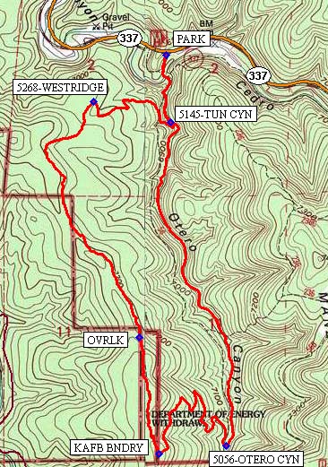
Actual HikeFor a short distance the hikers follow an old road which is the start of Otero Canyon trail (#5056) going south. Make an abrupt right turn (west) at 5145-TUN CYN (0.4 mi) where the trail goes uphill, right up the side of the canyon. Continue on the trail until the intersection with 5268-WESTRIDGE (0.8 mi) where you turn left (southwest). Turn around at OVRLK (1.9 mi) for a view looking northward toward the Sandias and I-40. At KAFB BNDRY (2.4 mi) turn left (east) heading into Otero Canyon. For the next half mile, there may be a good spot for lunch. Then at 5056-OTERO CYN (2.9 mi), turn left (north) to follow the Otero Canyon trail back to the van.
CommentsThe Otero Canyon West Loop hike trails are shown close to the middle-left of the Manzanita Mountains Trail System map.
Hike data were determined using a Garmin GPSMap 62 and Garmin BaseCamp’s DEM for TOPO US 24K Southwest.
WaypointsPARK: N35 02.085, W106 22.453
5145-TUN CYN: N35 01.864, W106 22.435
5268-WESTRIDGE: N35 01.933, W106 22.740
OVRLK: N35 01.162, W106 22.561
KAFB BNDRY: N35 00.782, W106 22.484
5056-OTERO CYN: N35 00.806, W106 22.212
Hike GPS File Name: OteroCynWestLp_BG.gpx
Hike GPS File: Click link to download hike waytrack file
Text Author: Bill Gloyd
Map Author: Bill Gloyd
Waypoints Author: Bill Gloyd
Track Author: Bill Gloyd
Maintainer: Bill Gloyd
Editor: Marilyn Warrant